World Wall Laminated Map

sku: COM9780007493104USED
ACCORDING TO OUR RECORDS THIS PRODUCT IS NOT AVAILABLE NOW
$39.46
Shipping from: Canada
Description
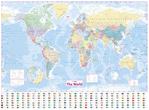
This laminated World Map has been fully updated to include the latest political changes, and contains politically colored mapping showing each country and their capital city, major roads, railways, and cities and towns clearly. Also included are national flags, key statistics for every country, and inset maps of the polar regions. This laminated (on front side only) map is ideal for any classroom, bedroom, or office wall. INCLUDES:· All recent political changes including the new independent country of South Sudan· Changes to international dateline AREA OF COVERAGEAll of the world, centered on the Greenwich Meridian, and including maps of the North and South Pole regions. SCALE1:22 000 000; 1 cm to 220 km; 1 inch to 347 milesSIZE54 x 40 inches OTHER VERSIONS AVAILABLEPaper flat map in tube (ISBN 9780007493111).
Price history chart & currency exchange rate
Customers also viewed

$22.25
2 Pcs Sink Anti-splashing Baffle Board Kitchen Water Splashing-proof Guard Flume Fixed Plate Tpr Retaining Plates
aliexpress.com


$10.74
USB C Type C to HDMI VGA 3.5mm Audio Adapter 3 in 1 USB 3.1 USB-C Converter Cable for Laptop Macbook Google
aliexpress.ru$4.36
Terlaris.. Direct Thermal Sticker , Stiker Label Online Shop BLUEPRINT 78 x 100 , 78x100 mm isi 300Pcs - 1 Roll 58
shopee.co.id$6.29
Quality Control✅Laverland crunch seaweed korea by manjun/ rumput laut snack sea salt|SQ4
shopee.co.id
$1.21
Harmonica 10 Holes Harp 20 C Tone Diatonic Harp key C Blues Jazz band mouth organ Harp Early Education Baby Music Sense Training
aliexpress.com
$39.50
Motorcycle Front or Rear Seat Driver Passenger Seat Pillion For Kawasaki Ninja 400 EX400 2018-2021 2020 2019 black
aliexpress.com
$1.69
Практичный Пинцет для наращивания накладных ресниц из нержавеющей стали, инструменты, антистатический пинцет, макияж, красота, индустриаль...
aliexpress.ru
$2.76
Baby Rattle Toys Black&White Animals Baby Bed Bell Safety Seat Plush Toy Baby Trolley Bed Wind Chimes Rattles Bell Crib Hanging
aliexpress.com
$6.57
Круглый Мощный Неодимовый магнит N35, 50/100 шт., диаметром 10x1, 12x1, 15x1, 18x1, 20x1, 22x1 мм, ремесленный постоянный магнит, Imanes De Neodimio
aliexpress.ru
$19.52
WLG Girls Overalls Kids Clothes Summer Floral Printed Overall Baby Girl Casual All Match Clothes for 2-8 Years
aliexpress.com

$2.53
stainless steel spice shaker pepper salt bottles connt jar container castor seasoning shelf jllbcm xhlight
dhgate.com

$2.11
Termurah !! GOODIE BAG IDUL FUTRI 30x40cm ( 1lusin) / tas bingkisan lebaran / tas parcel idul Fitri / tas spoundbond
shopee.co.id
$5.10
Кухня Бытовой 2 шт./набор Двусторонняя Губка для мытья посуды Посудное полотенце Чистый Сталь Мочалка для мытья Кухонные полотенца Аксессуары Инструменты 2pcs random color
joom.com
$4.58
2PCS H7 LED Car Headlight Bulb Base Adapter Holder Socket Retainer Suitable For HID Lamp Connector Replacement Parts
aliexpress.com