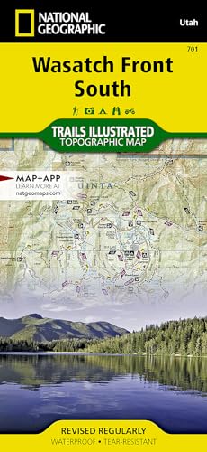
Wasatch Front South Map (National Geographic Trails Illustrated Map, 701)

артикул: COM9781566954488USED
ЗГІДНО З НАШИМИ ДАНИМИ, ЦЕЙ ПРОДУКТ ЗАРАЗ НЕ ДОСТУПНИЙ
$19.21
Доставка з: Канада
Опис
· Waterproof · Tear-Resistant · Topographic MapNational Geographic's Trails Illustrated map of Wasatch Front South is the most comprehensive guide for outdoor enthusiasts enjoying the year-round recreation activities in this region. Expertly researched and created in cooperation with the U.S. Forest Service and others, this map features key points of interest from Goshen and Juab Valleys in the west to Strawberry Ridge and Wasatch Plateau in the east. Coverage includes recreation hotspots Uinta and Manti-La Sal National Forests, Mt. Nebo Wilderness Area, San Pitch Mountains, Joes Valley Reservoir and Lake Canyon Recreation Area.Miles of mapped trails will lead you off the beaten path and back on again, including parts of the Great Western Trail, Arapeen OHV Trails and National Recreation Trails, all shown with mileage markers and labeled for motorized, non-motorized, snowmobile, OHV, ATV, motorcycle or Nordic ski use. Navigate the area using the map's contour lines, elevations, labeled peaks and summits, water features and clear boundaries of public recreation land as well as a complete road network, including numbered Forest Service roads. Camping guides show each campground's location, elevation, amenities, and number of sites. Other recreation features include trailheads, interpretive trails, campgrounds, boat ramps, climbing areas, fishing holes, dump stations and marinas. State and national scenic byways are labeled along with their roadside facilities for those wishing to explore the area by car. Every Trails Illustrated map is printed on "Backcountry Tough" waterproof, tear-resistant paper. A full UTM grid is printed on the map to aid with GPS navigation.Other features found on this map include: Manti-La Sal National Forest, Mona Reservoir, Mount Nebo Wilderness, Payson, San Pitch Mountains, South Tent Mountain, Spanish Fork Peak, Uinta National Forest, Wasatch Plateau, Wasatch Range.Map Scale = 1:75,000Sheet Size = 37.75" x 25.5"Folded Size = 4.25" x 9.25"
Графік зміни ціни & курс обміну валют
Користувачі також переглядали

$13.37
Solid Stainless Steel Watch Band for OB DW Longines L4 Comfortable To Wear Double Press Butterfly Buckle Watch Strap 14 18 20mm
aliexpress.com
$11.65
New Korean Stone Makeup Box with Mirror Ladies Handheld Makeup Bag Square Zipper Bathroom Organizer Packaging
aliexpress.com

$1,737.00
Aurelie Bidermann pulsera Paper Clip en oro amarillo de 18kt con diamantes - Dorado
farfetch.com


$12,454.00
TASAKI 18kt white gold Collection Line Balance step pearl and diamond pendant - Silver
farfetch.com

$23.90
2021 brand new men's Korean slim trend men's Denim Vest Large Foreign Trade locomotive vest shoulder holed men's Vest
aliexpress.com

$6.28
New Ear Hook Loop Replacement Bluetooth Repair Parts 6mm Transparent Soft Silicone Clip Headset Earphone Accessories
aliexpress.com
$12.68
Wireless Power Bank For Iphone 12 13 Pro Max 10000mAh Powerbank Induction Fast Chargrs Phone External Battery
aliexpress.com


$57.18
5-Speed Car Shift Knob Gear Shifting Lever for Mercedes-Benz Sprinter CDI 2000-2005
aliexpress.com
$169.06
G70-80 Para Lenovo G70-70 B70-80 Z70-80 I7-5500U motherboard AILG NM-A331 Rev1.0 DDR3L com GT840M/GT820M Teste 100% original
aliexpress.com
