Using Physical Maps

sku: COM9781512409499USED
ACCORDING TO OUR RECORDS THIS PRODUCT IS NOT AVAILABLE NOW
$19.53
Shipping from: Canada
Description
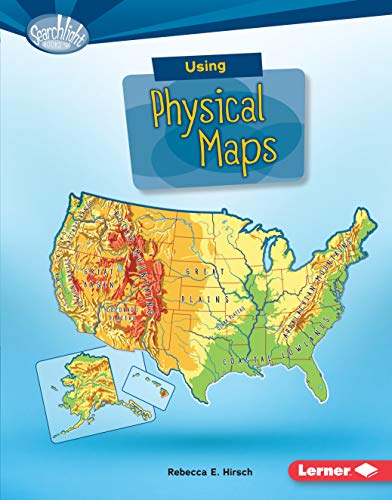
Have you ever wondered which countries have the most lakes? Or where the highest point in your state is? Physical maps show landscape features. They also often show land elevation, or how high the land is above sea level. But how do you use physical maps? And what do the different colors and symbols on these maps mean? Read on to learn all about physical maps!
Price history chart & currency exchange rate
Customers also viewed

$38.08
Diecast AF1 1:72 Scale China Z20 Yunlong Helicopter HongKong Garrison Alloy Aircraft Model Collectible Toy Gift Souvenir Display
aliexpress.com
$14.10
aHelloa, aHi, aGood Daya from the Blue Footed Boobies Throw Blanket Picnic funny gift Thermal Blankets
aliexpress.com

$8.60
5" Inch 125mm Mirka Autonet Mesh Sandpaper Abrasive Grid Dust Free Sanding Discs Net Sandpaper Anti-blocking 80-800Grit Car Pain
aliexpress.com
$124.20
Standing Desk Inches Height Adjustable Desk Whole-Piece Desktop Electric Stand up Desk Home Office Table for Computer Laptop
aliexpress.com
$8.31
Air Blower 5500RPM Portable Barbeque Air Blower for Barbecue Camping Cooking Fan Dropship
aliexpress.com


$42.20
Fashion Handbags Women Bags Genuine Leather Shoulder Bag Hobos Girls Crossbody Bag Designer Elegant Top-Handle Bags Female Tote
aliexpress.com
$0.10
Potentiometer knob without indicator half shaft knob 6mm d-axis 18.6 * 17mm potentiometer cap
aliexpress.com
, Logis с душевым гарнитуром (71400000, 71107000, 26275000)")
$446.90
Комплект смесителей Hansgrohe Logis с душевым гарнитуром (71400000, 71107000, 26275000), Logis с душевым гарнитуром (71400000, 71107000, 26275000)
techport.ru
, ART 1050IS 35 белый (в 2-х коробках)")
$382.93
Вытяжка HOMSair ART 1050IS 35 белый (в 2-х коробках), ART 1050IS 35 белый (в 2-х коробках)
techport.ru

$10.70
Sexy Women Clothes Seamless Set Fitness Leggings+Long Sleeve Cropped Top With Zipper Tracksuit Active Wear Gym Leggings Pants
aliexpress.com
$18.55
Size 47 Unisex Spring Summer Running Fit Shoes Men Air Mesh Sneakers Male Cushion Gym Sports Shoes Women Tenis Walking Footwear
aliexpress.com
$19.17
2 Pcs Crystal Nail Art Brushes Pen Holder Japanese Style Glass Container Metal Luxury Rose Gold Beauty Tools Storage
aliexpress.com
$10.99
10ft 20ft Length Plastic U-Molding U Moulding for 3/4" 19mm Width Arcade MAME Game Machine Amusement Cabinets Black
aliexpress.com


$11.96
CINESSD 2020 Summer New Unisex Outdoor Sport Sunscreen Baseball Hat Running Visor Cap Baseball Cap
aliexpress.com

$181.84
Матрас Beautyson ROLL SPRING Massage Cocos S1200 90х195, ROLL SPRING Massage Cocos S1200 90х195
techport.ru
$7.30
They Anchi Autumn Winter Ski Warm Men Gloves Thickness Non-Slip Climbing Cold-Proof Press Screen Windproof Riding Gloves
aliexpress.com
$48.12
ozuko health tote stray bag women 2021 new retro check large capacity shoulder bag messenger bag women
fordeal.com
$50.29
autumn new girls casual loose sweater pants suit 2pcs sweater children knitted suit winter girls clothing set baby girls clothes
fordeal.com
$24.22
Ruched Designed Sequins Dress Women Spaghetti Strap V Neck Mini Bodycon Dresses Sexy Night Party Dress Summer Stretchy Vestidos
aliexpress.com Inverted Pips-In Rubber Sponge Red/Black")
$2.73
NEW 2.2mm Pips-in Table Tennis (PingPong) Inverted Pips-In Rubber Sponge Red/Black
aliexpress.com
$18.36
Doppler Fetal Monitor Fetal Doppler 2.5M Prenatal Baby Heart Rate Detector Household Sonar Doppler Stethoscope Pregnant Women
aliexpress.com
$10.68
Summer Men Women Casual Loose Hippy Yoga Trousers Baggy Boho Aladdin Pants Adult Beach Casual Women Pants New Fashion 2020
aliexpress.com
$20.00
High Quality Stainless steel watchband 20mm 22mm silver black strap suitable for men's watch accessories Give tool
aliexpress.com

$12.50
High-end original quality gold cool love LOVE stud earrings, suitable for beautiful ladies to wear and enhance their temperament
aliexpress.com
$20.35
Vantage Lattice Canvas Bucket Bag Pu Splicing Women's Shoulder Bag Designer Small Crossbody Bags for Women 2021 Female Purses
aliexpress.com

$31.66
Baotou semi-slippers for women wearing summer Korean version of small clean metal buttoned wool shoes with thick heels Muller shoe
joybuy.com
$23.86
wireless Bluetooth 50 Earphone Pop-up 3D Stereo Earbuds Automatic sport Headset With Charge Box PJ0710-1310
joybuy.com
$39.00
Cigarloong cigar ashtray metal Large slot ashtray personality solid wood ashtray
aliexpress.com

