Historical Maps of the Napoleonic Wars

sku: COM9781856486514NEW
ACCORDING TO OUR RECORDS THIS PRODUCT IS NOT AVAILABLE NOW
$57.67
Shipping from: Canada
Description
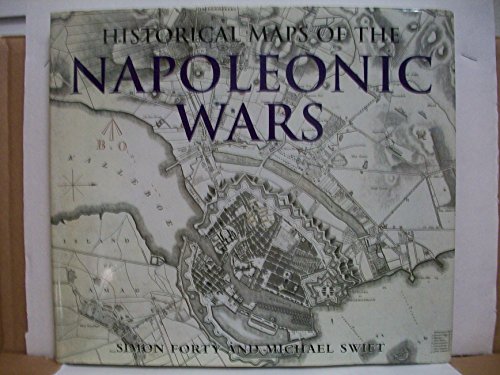
Based on the unique collection at the Public Record Office at Kew, England, this amazing assortment of more than 100 military maps charts the Napoleonic conflict from its start in 1803 to the defeat at Waterloo in 1815. Each one is beautifully hand drawn, accompanied by a caption explaining its significance. The maps reveal in fascinating detail how the events were plotted out, including the major battles at Trafalgar and Austerlitz. Follow the fighting and clashes in the Eastern Front in Germany, Russia, and Austria; the Southern Front in Spain and Portugal; and the crucial encounters in Belgium. Simon Forty, a highly praised military writer, presents a concise history of both the war and military mapping. This collection is an essential compilation, providing a unmatched insight into the organization of one of the greatest campaigns of all time.
Price history chart & currency exchange rate
Customers also viewed

$3.04
400ml Portable Electric Self Stirring Coffee Mug Office Glass Self Mixing Mug Automatic Electric Protein powder Mix Cup for Home
aliexpress.com
$11.95
2024 африканские платья для женщин элегантные мусульманские модные Abayas Boubou Дашики Анкара наряды вечернее платье Дубай Кафтан Abaya Халат
aliexpress.ru
$44.60
Linhua кости прямые 4/27 хайлайтер медовый блонд 13X4 прозрачные кружевные парики Remy 13X6 кружевной фронтальный парик предварительно выщипанные с детскими волосами
aliexpress.ru

$7.90
Mark zuckerberg is a lizard - Paddy the baddy Throw Blanket warm winter Designers Blankets
aliexpress.ru


$2.34
2024 гель для ремонта кожаной отделки автомобиля, гель для ремонта кожи автомобильного сиденья, дополнительная восстанавливающая кремовая краска для обслуживания автомобиля, паста
aliexpress.ru
$12.41
Bodysuit Swimsuit Wear Resistant Solid Color Sling Belt One Piece Swimsuit Push Up Beachwear Bodysuit Swimwear for Travel
aliexpress.ru
$0.34
2 шт. Шлифовальная головка шлифовальное сверло шлифовальное колесо с шестигранным хвостовиком портативная Шлифовальная головка инструмент прочная зеркальная
aliexpress.ru
$25.60
Материнская плата для ноутбука Dell Latitude 3450 L3450 L3550 3550 с 3205U/I3-5005U/I5-5200U
aliexpress.ru
$206.55
1200 Вт Электрический Стальной гибочный станок, стальной стержень 16/20/22 мм, Электрический Стальной станок для плоского железа, стальной гибочный станок
aliexpress.ru
$46.59
Наклейка на автомобильную педаль с логотипом для MG MG4 ZS HS, Usb-порт для зарядки, цветная градиентная защитная полоса порога
aliexpress.ru
$12.98
7/8" 22mm Handlebar Grips For SUZUKI GSX1100F GSX 1100F GSX1100 F 1991 1992 1993 Motorcycle Accessories Hand bar Cap Ends Plug
aliexpress.ru
$97.00
nt59 card amulet pendant women's 18k rose gold plated colorless red jade cord chain simple necklace, Silver
dhgate.com
$9.72
design brooch women letter leather through brooches suit pin gold plated fashion jewelry clothing decoration accessories, Gray
dhgate.com

$4.12
Новая повязка для волос, эластичная синтетическая коса из крупных волос, 5 прядей, плетеные косички, аксессуары для волос в стиле ретро, головной убор
aliexpress.ru
$9.93
100 шт. винты для слива желоба из листового металла крепежные винты для желоба нержавеющие винты для желоба для дерева алюминия других материалов
aliexpress.ru


$39.16
speaker handle pad thickened protective sleeve pad strap compatible for boombox1/2/3
fordeal.com
$46.01
FUNIER Family Christmas Pajamas Sets Cartoon Monster Print Sizes for Adult-Kids-Baby-Pet 2-Piece Top and Pants Bodysuits Xmas Pjs Set
walmart.com
$20.16
blouse women velvet shirt long sleeve turn down collar spring velour blusas solid lady casual clothe korean 210628, White
dhgate.com
$70.35
sandals designer womens classic sports foam slippers luxury comfort rubber sandals summer flat shoes mens and womens beach shoes, Black
dhgate.com
$157.17
2018 alvin and the chipmunks mascot costume chipmunks cospaly cartoon character halloween party costume carnival costume5803549, Red;yellow
dhgate.com

$413.94
Кардиган женский кашемировый, однобортный, свободного кроя, с геометрическим V-образным вырезом, зима 100%
aliexpress.ru

$15.10
Деревянные Геометрические кубики, игрушка-подставка, геометрическая форма, креативные подходящие игрушки, подарок для детей
aliexpress.ru
$10.53
2021 New Casual Men's Shorts Clothing Summer Funny Dog Printing Running Shorts Men's Polyester Sports Shorts Oversize for Male
aliexpress.com
$198.80
Женское кружевное платье со шлейфом, длинное платье с открытыми плечами и длинными рукавами, с вырезом на спине, FOF31118
aliexpress.ru
$6.00
32pcs Makeup Brushes Tool Set Cosmetic Powder Eye Shadow Foundation black Blush Blending Beauty Brush Maquiagem mutifunction
aliexpress.com
$20.99
Inspired by Ya Boy Kongming! Tsukimi Eiko Zhuge Kongming Cosplay Costume T-shirt 100% Polyester Pattern Harajuku Graphic Kawaii Vest For Men's / Sleeveless
miniinthebox.com
$12.34
ACT game Bloodborne concept t shirts game gift fans t shirts Bloodborne t shirt casual game tee shirt ac942
aliexpress.com
$13.99
Baby Carriers Cute Cartoon Pattern Multifunction Waist Stool Carrier Newborn Daily Out Portable Carriers Mother And Baby Produce
aliexpress.com
$64.89
MCU 8-bit PIC16 PIC RISC 7KB Flash 5V 20-Pin PDIP Tube - Rail/Tube PIC16F690-I/P
aliexpress.com
$4.40
Garden Supplies 8Patterns Water Nozzle Head Hose Sprayer Garden Spray Auto Car Washing home For garden vegetable patch
aliexpress.com
$49.50
EXP корпус трещотки-DT Swiss 12 Speed Micro Spline корпус трещотки-трещотки EXP12 x142/148 MS втулки 340/250EXP MTB
aliexpress.ru

$58.09
Оригинальное быстрое зарядное устройство для ноутбука SAMSUNG 7 серии 700G7A NP700G7A AD-200, 20019 Вт
aliexpress.ru
$14.00
Комплект ювелирных изделий DSHOU53, комплект из ожерелья и серег с подвеской в виде капли воды с кристаллами, 2 предмета
aliexpress.ru

")
