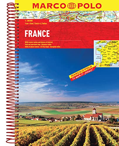
France Marco Polo Atlas (Marco Polo Road Atlas)

sku: COM9783829737418USED
ACCORDING TO OUR RECORDS THIS PRODUCT IS NOT AVAILABLE NOW
$12.44
Shipping from: Canada
Description
Marco Polo Atlases feature unique spiral binding with a wrap-around spine. The high quality cartography with distance indicators and scale converters aid route planning. A fold-out overview map is ideal for route planning and 7 self-adhesive Marco Polo mark-it stickers can be used to pin-point a destination or route for future reference. Scenic routes and places of interest are highlighted - ideal for touring holidays. They also contain a comprehensive index and inset streetplans of major cities. The scale is 1: 300 000. Includes inset maps of: Avignon, Bordeaux, Brest, Dijon, Grenoble, Le Harve, Le Mans, Limoges, Lille, Lyon, Marseille, Monaco, Nancy, Nice, Nimes, Orleans, Paris, Reims, Rennes, Rouen, Strasbourg, Toulouse. (Scales of inset maps vary.)
Price history chart & currency exchange rate
Customers also viewed

$1,125.88
Milling Cutter Drill Bit Grinding Machine All-in-one Machine Compound Sharpening Machine Tungsten Steel Universal Blade
aliexpress.com
$185.85
Чехлы на сиденья Automobiler для Skoda Rapid A-A-1462F2S382 Экокожа ромб, Черный, A-A-1462
goods.ruв")
$8.71
FORSAGE F5093 F-5093_набор ключей! Г-образных 6-гранных 9пр. (1.5, 2, 2.5, 3-6, 8, 10мм)в
goods.ru

$4.75
Van Gogh Art Painting Pencil Bag Custom Melee Starry Night Cute Pencil Cases Girl Boy Large Capacity School Supplies
aliexpress.com
$57.40
New Power Steering Pump For Honda Accord Petrol 2008-2012 56100R40305 56100-R40-325 56100-R40-A04 56100-R40-305 56100R40A04
aliexpress.com
$44.01
4g Elder Smart Watch Sim Video Call Recording GPS+Wifi Child Positioning Mobile Phone Sos Heart Rate Blood Pressure Boygirl Gift
aliexpress.com
$18.08
Кружевное атласное платье TRAF 2024, женское асимметричное Черное длинное платье без рукавов, женские вечерние платья средней длины, женское сексуальное платье
aliexpress.ru
$13.66
Костюм фэнтези Ночная сорочка женское сексуальное нижнее белье пикантное Нижнее белье Женская Соблазнительная горничная офисная форма Соблазнительный комплект для офиса
aliexpress.ru
$13.62
Браслет в стиле панк из нержавеющей стали в ретро-стиле для мужчин, винтажный черный дракон, украшенный зелеными глазами, фотоаксессуары для мужчин, подарки
aliexpress.ru
$14.58
Дополнительное колесо аксессуаров для газонокосилки съемное универсальное колесо для газонокосилки повышает эффективность работы
aliexpress.ru

$22.27
Женские кроссовки на шнуровке, Повседневная модная стильная обувь для отдыха, обувь для скейтборда, черные, AS-90
aliexpress.ru
$2.47
Подходит для электрической зубной щетки Oral-B, электрической чистящей щетки, сменной головки щетки, силиконовый розовый
aliexpress.ru
$29.56
Зимние утепленные куртки Lucyever из овечьей шерсти для женщин, Повседневная Верхняя одежда с длинным рукавом, пуговицами и лацканами, женские свободные теплые пальто из искусственного меха
aliexpress.ru
$9.61
Multi-grid Pens Pencils Holder Office Desk Organizer Desktop Stationery Storage Box
aliexpress.ru
$20.95
Кавайная Sanrios, мультяшная коричная спальня, маленькая ночь, светильник, украшение для спальни, атмосфера, Pat Night светильник, милый подарок на ...
aliexpress.ru
$16.00
Сексуальный милый купальник бикини phechion, религия Бога, Иисус, 3D принт, Модный летний пляжный купальный костюм для женщин, комплект бикини A10
aliexpress.ru
$0.30
Часы наручные мужские круглые регулируемые, сплав, портативный, аналоговые деловые, подарок на день рождения, тип 1
aliexpress.ru

$288.80
350ml Portable Blender USB Rechargeable Electric mini Juice Blenders Vitamer smoothie blender
aliexpress.com от, Белый;черный")

$71.20
Astronaut Fruit Plate Resin Character Model Nordic Home Decoration Accessories Living Room Bedroom Countertop Storage Sculpture
aliexpress.com

$35.98
ZAROYEAX Women Sandals Summer Heeled Hollow Slippers High Heel Shoes Fashion Shoes for Lady
walmart.com
$30.78
sandals style thick-soled wedges summer high, wild fashion trendy foreign trade size 43 roman shoes women, Black
dhgate.com
")


$48.94
street fashion brand wash men's used direct jet printing round ne pullover loose long sve sweater, Black
dhgate.com

$31.92
fashion womens blouses lace shirt summer apricot white puff sleeve korean clothing camisas mujer blusa 234c
dhgate.com
$15.92
sequined rhinestone tube womens cami crop sleeveless strap bra vest tank camisole, White
dhgate.com


$59.86
Outdoor Walking Retractable Dog Leash Rechargeable Pet Running One Handed Portable With LED Light Anti Slip Handle Free1
dhgate.com
$2.81
fashion lady bear printed cotton mask for valentines day can contain pm2.5 warm breathable mask sle #164#63011103
dhgate.com")

$11.76
20 LEDs Multifunctional Light String Night Lamp Easy Install Battery Powered Baby Shower Kids Nursery Room For Bedroom Printed
aliexpress.com
$2.48
Christmas Family Red Wine Bottle Set Santa Decoration Doll Hold Wine Setting Table Decoration
aliexpress.com
$37.83
Newest Fashion Pointed Toe Single Shoes Women Heels Office Lady Vogue Sexy Snake Pattern Pumps Size 35-40 Black
aliexpress.com![BLF1048 blf1048 [ SOT502A ] High-quality original LDMOS transistor](http://ae01.alicdn.com/kf/HTB1eEXrKv9TBuNjy0Fcq6zeiFXaE/BLF1048-blf1048-SOT502A-High-quality-original-LDMOS-transistor.jpg "BLF1048 blf1048 [ SOT502A ] High-quality original LDMOS transistor")

$24.54
1/6 Fashion Doll Model Scene Rocking Swing Chair Hanging Basket Chair Metal Frame Mini Sofa
aliexpress.com (черный) - Дисплей, экран для мобильного телефона")
$30.28
Дисплей для Acer Liquid Z530 с тачскрином, без рамки (0L-00029059) (черный) - Дисплей, экран для мобильного телефона
sidex.ru
