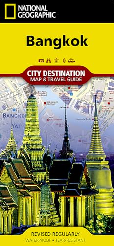
Bangkok Map (National Geographic Destination City Map)


sku: COM9781597754583USED
ACCORDING TO OUR RECORDS THIS PRODUCT IS NOT AVAILABLE NOW
$10.30
Shipping from: Canada
Description
· Waterproof · Tear-Resistant · Travel MapNational Geographic's City Destination map of Bangkok is both a comprehensive street map and travel guide, ideal for business and leisure travelers alike. The front of the map contains an overview of the public transit system along with maps of the Skytrain, Chao Phraya River boat service and Suvarnabhumi International Airport. Information is given about many popular attractions in and around the city. A user friendly index of streets, hotels, points of interest, public transit stops, markets, public buildings and much more, will help you find your destination quickly and efficiently. A regional map shows the city's location in Thailand's central plains. The reverse side features a comprehensive road map of the city and inset map of the Grand Palace and Wat Phra Kaeo, complete with pinpointed points of interest, monuments, theaters, places of worship, notable buildings and parks along with a multi-language legend. Many popular attractions are displayed in 3D, including the Grand Palace, Suan Pakkad Palace and Jim Thompson House. Public transit routes are clearly marked along with Skytrain, metro and water bus stations. Every Destination Map is printed on durable synthetic paper, making them waterproof, tear-resistant and tough — capable of withstanding the rigors of any kind of travel.Map Scale = 1:14,300Sheet Size = 24.75" x 17.75"Folded Size = 4" x 8.75"
Price history chart & currency exchange rate
Customers also viewed

$313.23
Makeup Beauty Salon Trolley Cosmetic Drawers Cleaning Tool Salon Trolley Hair Manicura Carrello Attrezzi Salon Furniture BL50ST
aliexpress.com
$2.32
1 Pair Faux Patent Leather Gloves Women's Novelty Arm Sleeves High Elastic Long Glove Black Full Fingers Cosplay Look Shiny Sexy
aliexpress.com
$7.96
4S 12V 800A BMS Li-Iron Lithium Battery Charger Protection Board with Power Battery Balance/Enhance PCB Protection Board
aliexpress.com
$45.31
Lasyarrow size 30-48 Women Boots Patent Leather Over The Knee Boots For Women Black Red Sexy High Heels Long Ladies Party Shoes
aliexpress.com
$95.66
Куртка детская H&M 1091620, цвет светло-синий, размер 128 (доставка из-за рубежа), 1091620
goods.ru
$25.99
Mens Japanese Anime Figure Graphic Kangaroo Pocket Drawstring Hoodies, Black;purple;blue
newchic.com
$20.33
горошек рябить стринги бикини купальники женщина 2020 push up узел передней бандо бикини строки купальник sexy mini pink black
dhgate.com
$27.29
creative mini stone storage box superior leather with mute magnet cover diamond display case gem jewelry holder organizer tray, Pink;blue
dhgate.com
$8.07
airbag anti fall for oneplus nord z 8 7 7t pro 5g 8pro 7pro fundas capas mobile housing cases world map travel just go
dhgate.com
$42.70
бф шикарные улица скейтборд с коротким рукавом футболки черно белые майки в настоящее время футболки мужские, White;black
dhgate.com
$36.93
повседневная лето 2019 очаровательная женская элегантный тонкий для похудения кружева шить платья полые галстук макси платье vestido де фест, Black;gray
dhgate.com
$4.08
новая салфетка сумка для хранения хлопка санитарные pad чехол портативный макияж сумка симпатичные портмоне прочный держатель ткани чехол
dhgate.com
$12.52
trouble letter printed t-shirt 2017 summer feminino women's lady loose short sleeve casual shirt tops new fashion t shirt, White
dhgate.com
$22.52
2019 new mortal kombat 11 3d hoodies men women spring fall winter casual fashion mortal kombat 11 hoodies sweatshirts, Black
dhgate.com
$36.82
nektom часы мужские водонепроницаемый аналоговые часы мода из нержавеющей стали водонепроницаемые luminous спортивные часы menrelogio мужчин, Slivery;brown
dhgate.com
$163.43
designer fashion backpack female designer luxury handbag leather bag handbag shoulder bag, large backpack 2020 new style
dhgate.com
$5.08
тело ювелирных сосок кольцо круглая кисточка соски наклейка женщина сексуальные ювелирные изделия груди мода красных черный сосок покрытие, Slivery;golden
dhgate.com
$20.42
каучуковый ремешок мужские часы аксессуары для воды дух di tong ghost king gmt водонепроницаемый силиконовый ремешок 20mm1, Black;brown
dhgate.com
$10.59
women Backpack designer fashion large capacity student's canvas School Bag back pack vintage patchwork Travel bag big daypack
aliexpress.com
$11.19
LED Wall Light Waterproof IP44 Indoor Bathroom Wall-mount Light Cabinet Bedroom Modern Wall Lamps 30cm 60cm
aliexpress.com
$14.03
CNC Aluminum Motorcycle accessories Motorbike Windshield Windscreen fairing cover For Yamaha MT07 MT-07 MT 07 FZ07 2013-2017
aliexpress.com
$20.40
New Volleyball sportwear sets,Polyester quick-drying Table tennis shorts,tennis sport shirt jersey,badminton t-shirts
aliexpress.com
$3.32
nordic viking stainless steel amulet Vegvisir Compass pendant necklace with gift bag
aliexpress.com
$2.54
Girls Blouses Cotton Kids Clothing Girls Ruffle Top Children Blouse Kids Blouses Shirt Long Sleeve Tops Children Shirts For Girl
aliexpress.com
$2.46
Motorcycle sticker moto pegatinas Gas oil tank pad Protector Decal For Kawasaki z900 z750 accessories ninja 300 er5 z1000sx er6f
aliexpress.com
$2.21
Women Cat Claw Strawberry Print Cute Lovely Panties Seamless Low Waist Girl Underwear Ruffle Princess Female Breifs Lingerie
aliexpress.com


